
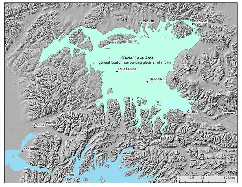
Researchers have long recognized that, at one time, vast inland lakes existed in what is now Ahtna country, formed by glaciers during the ice ages. There have been at least five significant ice ages in Earth’s history, with approximately a dozen epochs of advancing glaciers alternating with warmer periods when the ice melted and retreated. In the Copper River/Susitna River basins, advancing glaciers periodically blocked the river drainages near the mouth of the Chitina River, the middle Susitna River Valley at Devils Canyon, in the upper Matanuska Valley at Tahneta Pass, and in the Alaska Range at Mentasta Pass. Approximately 58,600 years ago, these blockages resulted in the formation of massive, long-lived glacial lakes, referred to as Glacial Lake Susitna and Glacial Lake Atna.
The process was dynamic. Glaciers advanced and retreated and, as they did, the levels of the lakes repeatedly rose and fell. Evidence suggests that Lake Susitna rose from its beginning in the Susitna River Basin to fill both the Susitna and Copper River valleys with one great waterbody. Later it drained and split into eastern Glacial Lake Atna and western Glacial Lake Susitna. With the most recent glacial advance, Glacial Lake Susitna’s levels again increased, merging and overtaking Lake Atna. At this point, the lake is referred to by both names although Glacial Lake Atna is currently preferred.
During periods of glacier retreat, ice at times blocked the narrow outlets. Sometimes these dams failed catastrophically, causing great floods. Glacial Lake Atna burst through ice dams at Mentasta Pass at least two times, forming delta outwash beds stretching downstream from the Pass into the upper Tanana River. Some researchers think that Glacial Lake Susitna at one time burst down the Matanuska Valley at Tahneta Pass, leaving grooved and scour-marked hills and a series of parallel dunes west of Wasilla near the far end of its passage. Its final draining could have happened either through Devils Canyon on the Susitna River or southwest of the present-day Stephan Lake. The last waters of Glacial Lake Atna likely drained down the Copper River and south into the Pacific Ocean about 10,000 years ago, leaving behind remnants including Tazlina Lake, Klutina Lake, and Tonsina Lake.
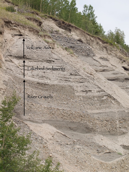
Recently, archeologists at Wrangell-St. Elias National Park, in cooperation with Ahtna, Inc., completed a 4-year study which identified projected Lake Atna shorelines in and around the Park, and surveyed those features for evidence of human activity. The highest-probability areas turned out to be a series of exposed ridge systems which roughly circle the south and west flanks of Mount Drum and Mount Wrangell and the north and west flanks of Mount Sanford. These ridges, located on or near projected Lake Atna shorelines, were in place before the formation of Lake Atna, and would have offered the best paths of travel for people following large game or circumnavigating the lake for other purposes. The ridge systems also form a direct path to higher-elevation areas ideal for upland hunting activities. It is likely that these ridge systems would have served as a travel corridor even after lake levels went down. Significantly, Ahtna oral history documents a well-used trail in the same vicinity, Taghael Dze’ Tene (the trail to Taral). The project identified 69 individual archeological sites. Most of them consisted of stone tools and tool-making debris. One of the sites, located in the northern Copper River Basin near the northeastern boundary of Lake Atna, yielded a buried hearth feature which dated to 11,324-12,188 years ago.
Continued excavation at the site, lead by researchers at Texas A&M University, uncovered an older hearth feature which dated to approximately 13,000 years ago. The site has since been formally named Nataeł Na’, the traditional Ahtna place name for Tanada Creek, which runs adjacent to the site.
Many interesting things will be learned from this project as researchers study the findings and compare them with other evidence. One conclusion already drawn is that a reliably dated archeological site situated on a Lake Atna shoreline provides firm evidence that the level of Lake Atna was at or below the 777-meter shoreline level when it was occupied approximately 12,000 years ago. That in turn strengthens the developing time chronology of ancient Lake Atna.
Sources:
- Archaeology on the Shores of Ancient Lake Atna: The Excavation of NAB-00533 with John T. White, Texas A&M University February 2021. http://www.wise-edu.org/science-lecture-series.html.
- Geoarchaeology of Glacial Lakes Susitna and Atna. Smith, Gerad. 2019.
- Late Quaternary megafloods from Glacial Lake Atna, Southcentral Alaska. Wiedmer, M., et al. 2010.
- Archaeology on the Shores of Ancient Lake Atna with Lee Reininghaus, Wrangell-St. Elias National Park February 2021. http://www.wise-edu.org/science-lecture-series.html.
- Tatl’ahwt’aenn Nenn’: Headwaters People’s Country. Kari, James, transcriber and editor. 1986. Alaska Native Language Center, University of Alaska Fairbanks.